A-Register in Tamil Nadu: How to Read It Before You Buy Land
How to view and read Tamil Nadu's A-Register on TN eServices, what its 16 fields mean for due diligence, and which entries should stop a land deal.
Vignesh Nagarajan · · 17 min read · Source: Government of Tamil Nadu (Revenue Department)
On this page
- In short
- Use the A-Register as one layer of evidence, not proof of title
- Pull each record at the right stage
- Read all 16 fields of the extract
- View the extract on TN eServices
- Check government or private status before you talk price
- Map old survey numbers to new ones before you rely on a deed
- Know which entries stop a deal and which need a follow-up
- Reconcile the A-Register with Patta, FMB and EC
- Use TSLR, not the A-Register, for town-surveyed land
- Plan the land-use conversion before you commit
- Put the A-Register first in your due diligence
- What this means for you
This guide is for land-acquisition teams, plot buyers and sellers reading a rural or Natham parcel in Tamil Nadu. It covers the A-Register, not title opinions or urban town-survey land, and portal labels can change.
In short
- Pull the A-Register first on a rural parcel. Before any token advance it shows whether the land is private or government, its type, the subdivision’s size and the linked Patta.
- It records what the revenue office holds, not who holds valid title. The Supreme Court has held that revenue entries do not confer title.
- Field 5 (Government or Ryotwari) is the first stop-or-go check. A Government entry or a Poramboke result should halt the deal until you have the revenue office’s written position and legal advice.
- Match survey number, subdivision, extent, Patta number and names against the Patta, FMB, deed and Encumbrance Certificate before you pay an advance.
- A Nanjai (wet) or Punjai (dry) entry does not bar a purchase. It stops non-agricultural development until the right permission is in hand.
Use the A-Register as one layer of evidence, not proof of title
The A-Register is a village land register for rural and Natham land. The Commissionerate of Land Administration says the A-Register and the Chitta were computerised using the Tamil Nilam software, and that computer-generated extracts can be downloaded under the state’s “Anytime Anywhere” e-service. The TN eServices land-records site is the government’s route for viewing them today.
The Supreme Court has held that entries in revenue records do not confer title and serve a fiscal purpose (Suraj Bhan v. Financial Commissioner, 2007), and that mutation neither creates nor extinguishes title (Mansoor Saheb v. Salima, 2024). Use an extract as one layer of the evidence, never the only check.
| Record type | What it confirms | What it does not confirm |
|---|---|---|
| A-Register extract | Survey and subdivision, government or private status, land type, extent, assessment, linked Patta number | Valid title, current use on the ground, planning permission |
| Patta and Chitta | Recorded holder and the subdivisions held under that Patta number | Title chain, encumbrances, boundary disputes |
| Sale deed | Conveyance, parties, consideration, schedule of property | Freedom from encumbrances, marketable title |
| Encumbrance Certificate | Registered transactions at the SRO | Unregistered interests, revenue disputes |
Pull each record at the right stage
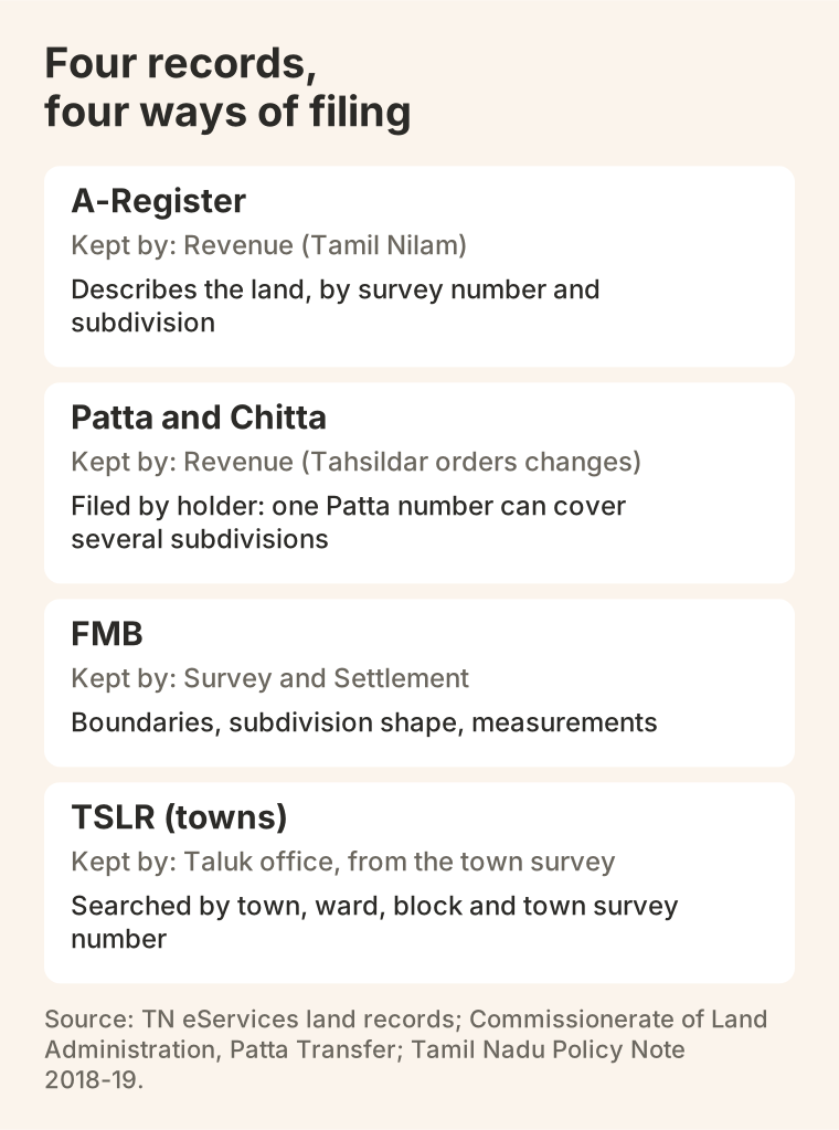
The A-Register is organised by survey number and subdivision and describes the land. The Patta and Chitta are organised by holder, so one Patta number can cover several subdivisions. Changes to both follow orders of the Tahsildar at the Taluk office, such as a transfer of registry or a subdivision. Boundaries and subdivision shapes come from the Survey and Settlement Department, and registered transactions from the Registration Department.
The A-Register comes at the earliest stage, with the Patta and Chitta, to confirm survey identity and classification. Get the FMB / TSLR sketch before making an offer, and whenever extent or boundary is in doubt. Pull the Encumbrance Certificate (Registration Department, SRO, TNREGINET) after confirming survey identity, for the full transaction period. Add a master-plan or local-body confirmation when use or conversion is a concern.
Read all 16 fields of the extract
The TN eServices result shows the district, taluk and village as a header, then one numbered row for the requested survey and subdivision. The fields below follow a TN eServices result that Proquiro reviewed field by field.
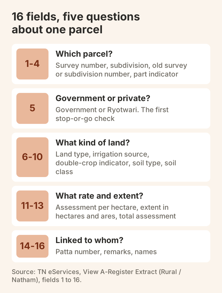
- Fields 1 to 4, the parcel. Survey number, subdivision number, old survey or subdivision number, and the part indicator. Fields 1 and 2 must match the deed schedule, Patta and FMB. Field 3 bridges old deeds to the current number. For field 4, ask the revenue office what the part covers.
- Field 5, Government or Ryotwari. Recorded as government or private (ryotwari) land. This is the first stop-or-go check.
- Fields 6 to 10, the land. Land type (for example Nanjai, wet, or Punjai, dry; a house-site type for Natham land), irrigation source, double-crop indicator, soil type and soil class. Land type sets the conversion route and affects value. The rest is context or informational.
- Fields 11 to 13, rate and extent. Assessment per hectare, extent in hectares and ares, and total assessment in rupees and paise. Convert the extent before comparing it with a deed in acres and cents. The assessment fields are informational, not a parcel-identity test.
- Fields 14 to 16, Patta and names. The Patta number must equal the Patta being checked. Read every remark, because some cite orders. Compare the names with the Patta and the seller; with several owners, the extract may show the first name and a count.
View the extract on TN eServices
The TN eServices land-records portal shows an extract. It is not where you apply to change the record.
- Open the portal. Go to eservices.tn.gov.in and choose View A-Register Extract (Rural / Natham). For land in a town-surveyed area, use TSLR Extract instead.
- Select the location. Choose the district, taluk and village exactly as they appear on the Patta or the deed, then choose Rural or Natham.
- Enter the survey details. Enter the survey number, then pick the subdivision. For survey 24/2A, enter 24 as the survey number and 2A as the subdivision; use ”-” where the survey has no subdivision.
- Confirm with a mobile number. The portal asks for a mobile number and a one-time password before it shows the extract.
- Check and keep it. Check every field against the Patta and the deed schedule, then save or print the extract with the date it was viewed. The extract reflects what Tamil Nilam held on that date.
Applications to change the record go elsewhere. Patta transfer applications are filed on the Tamil Nilam Citizen Portal, which the eServices home page links as “Apply Online Patta Transfer”, or through a Common Service Centre. The patta mutation guide covers that route.
Proquiro’s A-Register page takes the same district, taluk, village, survey and subdivision details and then continues on ViewPatta, Proquiro’s consumer service. ViewPatta signs you in with your mobile number and prepares the A-Register row from Tamil Nadu eServices data. It searches by survey number and subdivision.
It is a paid service: the price is quoted once the record is prepared, and you pay before you can download it. Its document is an information copy that omits the government barcode and verification reference. It is not a government document. When you need the portal’s own extract with its barcode reference, use TN eServices itself.
If a search returns no record, check the inputs first. Common causes are a different spelling or a newer district after a bifurcation, a taluk created after the deed, an old panchayat name instead of the revenue village name, and an old survey number or a subdivision split again after the deed. Check the Correlation Statement and the FMB, and ask the Taluk survey section. A failed search is not proof that the deed is wrong.
Check government or private status before you talk price
Two fields carry the classification. Field 5 says whether the land is government or private (ryotwari). Field 6 gives the land type. Poramboke status is checked separately: TN eServices has an option to verify whether land is Government or Private (Poramboke).
| Value | What it means | Acquisition implication |
|---|---|---|
| Ryotwari (field 5) | Land recorded as private (ryotwari) | The expected value for a private parcel |
| Government (field 5) | Land recorded as government land | Stop. Have counsel check for an assignment order or a ryotwari Patta before any advance |
| Nanjai (wet) | Land recorded as wet | In a non-planning area, the Director obtains the District Collector’s prior concurrence first; see the conversion section below |
| Punjai (dry) | Land recorded as dry | The dry-land conversion route applies |
| Natham | Village house-site land | Do not assume it is private, or that it is barred. Occupied house-sites can be private, while Natham poramboke may be government land. Ask for the house-site Patta or assignment order |
| Poramboke (eServices) | Land recorded as set apart for public or communal use | Halt the deal, run the eServices Government or Private check, and get the revenue office’s written position and a title opinion before going on |
The label alone does not settle the question either way; the assignment order, Patta and title documents do. A Government entry or a Poramboke result should halt the acquisition until the team has the revenue office’s written position and independent legal advice.
Map old survey numbers to new ones before you rely on a deed
Tamil Nadu’s village records come from several rounds of survey and updating: the early twentieth-century resurvey (1905–1926), the Updating of Registry (UDR) scheme of 1979–1987 and the Natham Survey. A modern DGPS-based resurvey has so far covered only part of the state, so many parcels still carry numbers from the earlier rounds. Older deeds may use a number from before UDR or a later subdivision.
- Deed uses an old survey number; the A-Register shows a new one. Check field 3, then the village Correlation Statement published by the Survey and Settlement Department and linked from eServices.
- The A-Register extent differs from the deed. Check whether a subdivision or a later survey round changed the extent. Compare the FMB sketch for the current subdivision with the deed’s schedule in the same units.
- The subdivision differs between the A-Register and the Patta. One record may not yet reflect a recent subdivision. Pull a fresh Patta and A-Register extract and get the Taluk office’s written confirmation.
When old and new numbers cannot be reconciled online, the FMB and a visit to the Taluk survey section are the next step.
Know which entries stop a deal and which need a follow-up
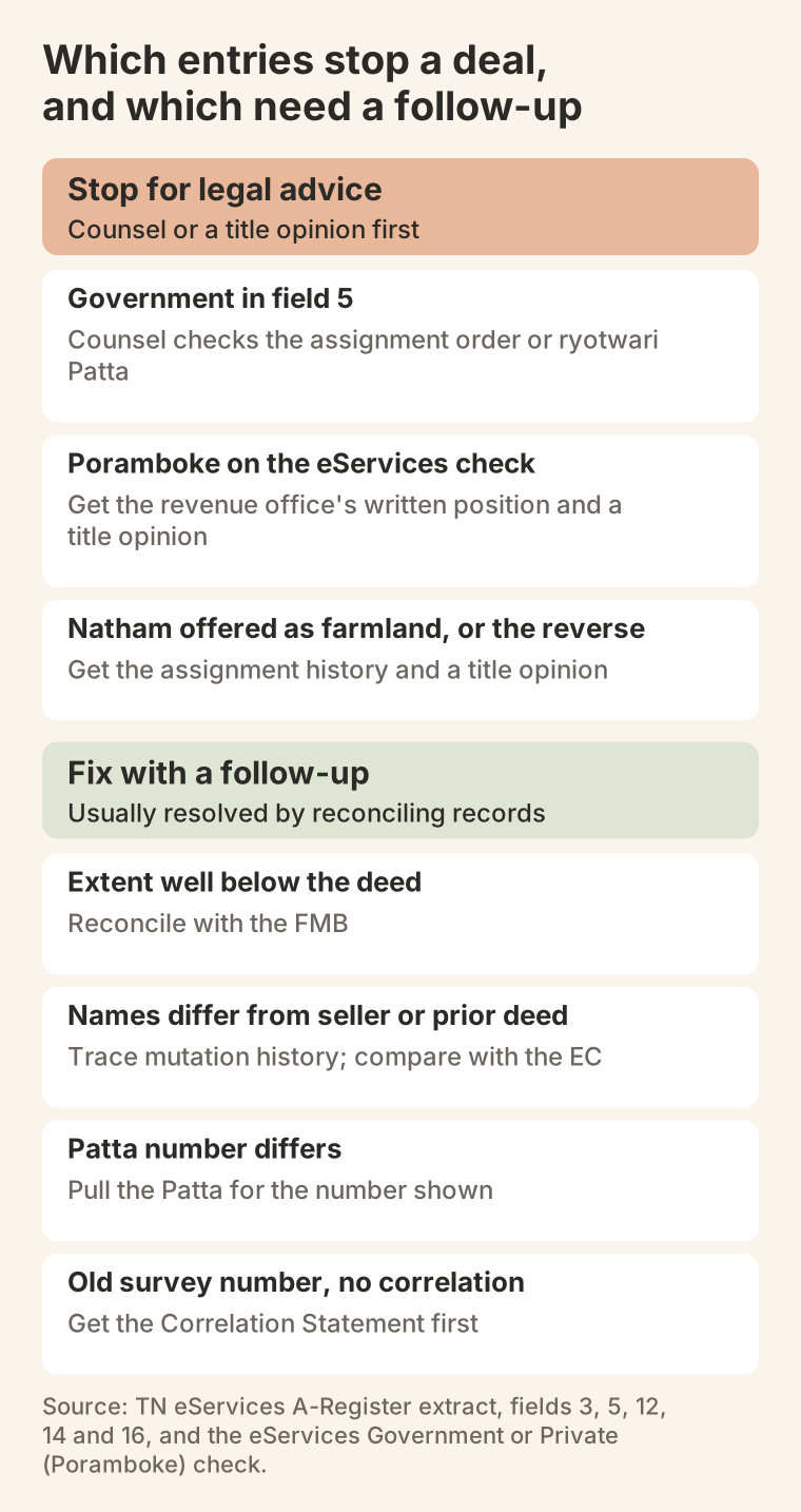
Most A-Register issues can be resolved with the right follow-up; some cannot without legal work. Separate the two before any advance payment. A Government entry and a Poramboke result, covered above, are the first kind of stop; the chart sorts seven entries.
| Red flag | Why it matters | Minimum action |
|---|---|---|
| A-Register extent well below the deed | Part of the deed schedule may cover another subdivision | Reconcile with the FMB; check what the title actually covers |
| Names do not match the seller or the prior deed | A transfer may not have been mutated, or a different parcel was selected | Trace the mutation history and compare with the EC for the period |
| Patta number differs from the Patta being checked | The Patta may cover other subdivisions, or the wrong row was pulled | Pull the Patta for the number shown and reconcile |
| Natham land offered as farmland, or farmland offered as a house site | Transferability depends on the assignment history | Get the assignment history and a title opinion |
| An old survey number with no correlation | The deed may not map to the current record | Get the Correlation Statement or the Taluk survey section’s confirmation first |
In Proquiro’s workspace, the document-verification feature lets an admin or manager verify an uploaded land-record document such as an A-Register, or reject it with a reason such as Data mismatch and a written note, with the action recorded in the audit log. It does not read the classification from the document.
Reconcile the A-Register with Patta, FMB and EC
No rural parcel review is complete with the A-Register alone. A mismatch with the Patta on survey number, subdivision, extent or Patta number can mean one record is outdated, a different parcel was selected, or a correction is pending. Investigate it before any advance payment.
Compare these fields across the records:
- Survey and subdivision (fields 1 to 3) with the Patta, FMB and deed schedule.
- Patta number (field 14) with the Patta being checked.
- Extent (field 12) with the Patta, FMB and deed schedule, converting units first.
- Classification (fields 5 and 6) with the Patta land type and the planning authority’s land-use zone. The revenue type does not answer what the master plan allows; check both.
- Names (field 16) with the current Patta holder and the EC for the SRO period.
- Village and taluk (header) with the deed recital and SRO jurisdiction. The EC may have been pulled for the wrong SRO.
Record every material discrepancy and get the responsible office’s written clarification before the legal report. The Encumbrance Certificate anchors the registered transaction history; confirm the SRO jurisdiction in the Tamil Nadu SRO directory before pulling it, particularly for parcels near a zone or district boundary.
Use TSLR, not the A-Register, for town-surveyed land
The A-Register covers village-surveyed rural and Natham land. TSLR, the Town Survey Land Register, is the closest urban counterpart: a register of town survey numbers with extent, assessment, owners and land use. It exists only where a town survey has been done, which means municipalities and corporations that have been town-surveyed. The Chennai Metropolitan Planning Area is a planning boundary, not a survey boundary: it includes town panchayats and many revenue villages that use village records.
- Area covered: the A-Register covers village-surveyed land; TSLR covers towns that have been town-surveyed.
- Identifier: the A-Register uses survey number and subdivision within district, taluk and village; TSLR uses town survey number and subdivision within town, ward and block.
- TN eServices option: View A-Register Extract (Rural / Natham) or TSLR Extract.
- Boundary sketch: FMB (Field Measurement Book) or TSLR sketch.
- Maintained by: the A-Register is a village record in Tamil Nilam; TSLR is kept by the Taluk office from the town survey. The Tahsildar orders changes to both.
Check on TN eServices whether the parcel’s town or village is listed as urban or rural before choosing the record. On Proquiro, the Patta/Chitta page has an Urban TSLR mode and the FMB/TSLR sketch page covers the urban sketch; both continue on ViewPatta.
Plan the land-use conversion before you commit
A Nanjai or Punjai entry does not bar a purchase, but it does stop non-agricultural development until the right permission is in hand. The market shorthand is “NA conversion”; the legal step is a change of land use from agriculture to non-agriculture. Which route applies depends first on where the land is.
- Outside a notified planning area, the 2017 Change of Land Use Rules apply: development permission from the local authority after the Director of Town and Country Planning’s prior concurrence. For wet land (Nanjai), the Director obtains the District Collector’s prior concurrence first. For dry land (Punjai), the Director decides on the affidavit, Chitta and Adangal uploaded under rule 3(2) (G.O. Ms. No. 149, 31 July 2026).
- Inside a notified planning area, the master-plan zone decides, for wet and dry land alike. A use the zone does not permit needs reclassification: by CMDA in the Chennai Metropolitan Planning Area, and by the DTCP or the local planning authority elsewhere.
Natham is house-site land, not agricultural land, so the agriculture-to-non-agriculture route is not the starting point. Whether commercial or industrial use is allowed depends on the master-plan zone or the local body’s permission, and on the parcel’s assignment history.
Tamil Nadu Act No. 14 of 2026, which received assent on 12 September 2026, amends section 47-A of the Tamil Nadu Town and Country Planning Act to move the wet-land concurrence from the Collector to the Director. It takes effect only on a date the Government notifies, so plan for the Collector’s concurrence until then.
The agricultural land conversion guide sets out each route and the evidence to hold. Make the permission a condition of the deal.
Put the A-Register first in your due diligence
Pull the A-Register before any advance payment or letter of intent. It can rule a parcel out (a Government entry, a Poramboke result) or point to a specific cross-check (an extent gap, an old survey number) before lawyers spend time on a full title search.
- Identify the parcel. View the extract with the seller’s survey details and confirm the classification, extent and Patta number.
- Reconcile the records. List every difference from the Patta, FMB and deed schedule.
- Triage the red flags. A Government entry, a Poramboke result, Natham land, part entries and any large extent gap: stop, escalate for legal advice, or clear.
- Map old to new. Resolve any old survey number with the Correlation Statement.
- View it again after purchase. After the patta transfer, confirm the new holder appears against the subdivision.
Move on when the A-Register matches the Patta and deed and the classification suits the plan; otherwise hold the advance and keep a list of open issues.
Use the Tamil Nadu land due-diligence checklist for the order of record checks. Teams that need each check assigned can use Proquiro’s task management (Pro plan and above) and document verification. The patta mutation guide covers the step after a registered purchase: confirming that the Patta and the A-Register show the new holder, and what to do when the village record does not update promptly.
What this means for you
A developer’s land team: Pull the A-Register first, before any advance or letter of intent. Treat a Government entry or a Poramboke result as a halt, and make conversion permission a condition of the deal for any Nanjai or Punjai parcel.
A single-plot buyer: Read fields 1, 2, 5, 12 and 14 against your deed and Patta before you pay anything. If the extent, Patta number or names differ, ask the revenue office to explain in writing and do not treat the extract as proof that the seller owns the land.
A land owner or seller: Check the extract against your Patta and deed before you advertise. If an old survey number, a part indicator or a Natham entry is on the row, bring the Correlation Statement, assignment history or house-site Patta so a buyer’s team can reconcile it quickly.
Sources and editorial notes
Methodology
The A-Register fields follow a TN eServices result that Proquiro reviewed field by field in July 2026. The retrieval steps, survey history, conversion route and case law were checked against the official sources listed here on 4 November 2026.
Sources
- Tamil Nadu eServices — Land Records — Government of Tamil Nadu (Revenue Department)Primary source · Checked
- Patta Transfer — Commissionerate of Land Administration, Tamil Nadu — Commissionerate of Land Administration, Government of Tamil NaduPrimary source · Checked
- Policy Note 2018–19 — Commissionerate of Survey and Settlement, Government of Tamil NaduPrimary source · Checked
- Scanned Correlation Statements (district, taluk and village lookup) — Commissionerate of Survey and Settlement, Government of Tamil NaduPrimary source · Checked
- Tamil Nadu Change of Land Use (From Agriculture to Non-agriculture Purposes in Non-planning Areas) Rules, 2017 — India CodePrimary source · Checked
- G.O. Ms. No. 149 — dry-land concurrence under the change-of-land-use rules, 31 July 2026 — Tamil Nadu Stationery and Printing DepartmentPrimary source · Checked
- G.O. Ms. No. 53 — 2025 amendment to the non-planning-area change-of-land-use rules — Tamil Nadu Stationery and Printing DepartmentPrimary source · Checked
- Tamil Nadu Act No. 14 of 2026 — amendment to section 47-A of the Tamil Nadu Town and Country Planning Act — Tamil Nadu Stationery and Printing DepartmentPrimary source · Checked
- Suraj Bhan v. Financial Commissioner, 2007 — Supreme Court of India (via Indian Kanoon)Primary source · Checked
- Mansoor Saheb (Dead) v. Salima (D) by LRs, 2024 INSC 1006 (19 December 2024) — Supreme Court of IndiaPrimary source · Checked
- Tamil Nilam Citizen Portal — Government of Tamil Nadu (Revenue Department)Primary source · Checked
Questions
Check the village A-Register entry
ViewPatta, our consumer service, is paid. It prepares the A-Register row from the survey and subdivision and shows the price before payment.
Continue reading
G.O. 194 explained: 19.50m replaces 18.30m in listed building rules
HUD G.O.(Ms) No. 194 of 26 October 2026 replaces 18.30m with 19.50m in listed TNCDBR rules and amends others, including zoning, road width, parking and pools.
Agricultural Land Conversion in Tamil Nadu: Which Route Applies
Which Tamil Nadu land-conversion route applies to a parcel: non-planning area rules, planning-area reclassification, charges, documents and coastal limits.
Stamp Duty and Registration Charges in Tamil Nadu: 2026 Guide
Tamil Nadu stamp duty and registration charges by document type: sale deeds, gifts, settlements, partitions, mortgages and first sales, with worked examples.